![]()
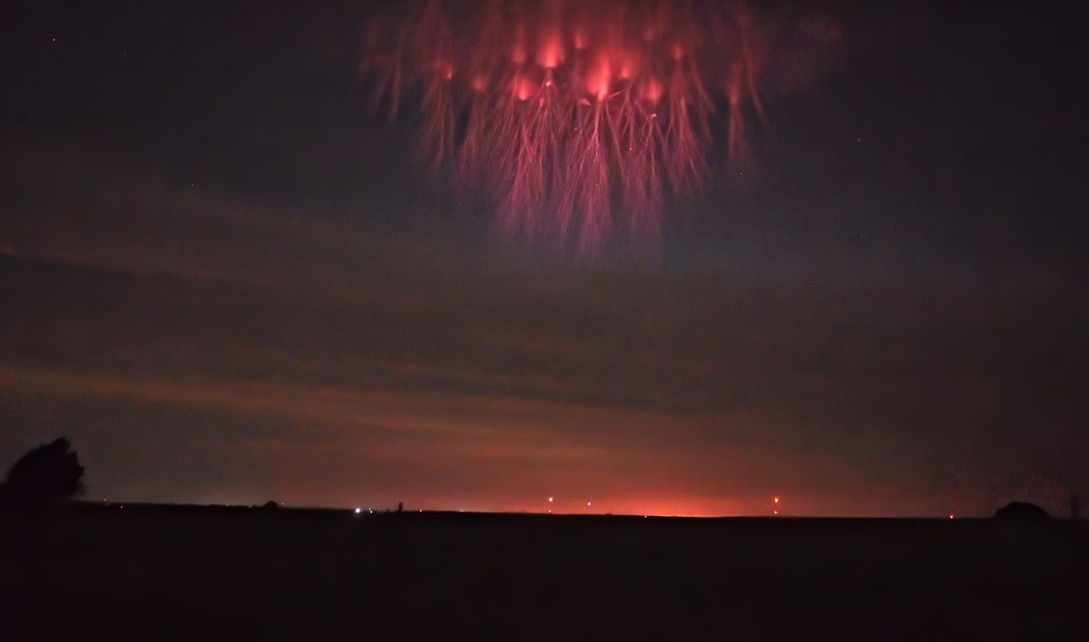
Image Credit & Copyright: Stephane Vetter (TWAN)
What Are Red Sprites and How Do They Form?
Sprites Or Red sprites are terms used to describe large-scale electrical discharges occurring high above thunderstorm clouds or cumulonimbus (Transient Luminous Events – TLE). These are often triggered by positive lightning discharges between an underlying thundercloud or the ground. This gives rise to a wide range of visual shapes in the night sky.
Sprites are luminous flashes of reddish-orange light. They are often found in groups above the troposphere at altitudes of 50-90 km (31 to 56 mi). Although there are occasional visual reports of sprites dating back to at least 1886, they were first photographed by scientists at the University of Minnesota on July 4, 1994. They have since been captured in video recordings thousands of times.
Sometimes, sprites are incorrectly called “upper-atmospheric lighting”. Sprites are cold plasma phenomena, which lack the high channel temperatures of tropospheric lightning. They are therefore more similar to fluorescent tube discharges rather than lightning discharges. Sprites can also be associated with other optical phenomena in the upper atmosphere, such as blue jets or elves.
History Of Red Sprites
Johann Georg Estor, in 1730, is the first person to have reported transient optical phenomena over thunderclouds. Toynbee & Mackenzie also reported this phenomenon in 1886. C. T. R. Wilson, Nobel laureate, had proposed in 1925 that an electrical breakdown could take place in the upper atmosphere. In 1956, he saw what could have been a sprite. Photographically, they were first captured by scientists at the University of Minnesota using a low-light camera.
After their discovery, they were named “sprites” (air spirits) for their mysterious nature. Spites have been photographed from ground, air, and space since 1989’s video capture. This has led to intensive research into the meteorological phenomena.
2016 saw the passage of Hurricane Matthew through the Caribbean. Spites were seen. It is currently unknown what the role of sprites is during tropical cyclones.
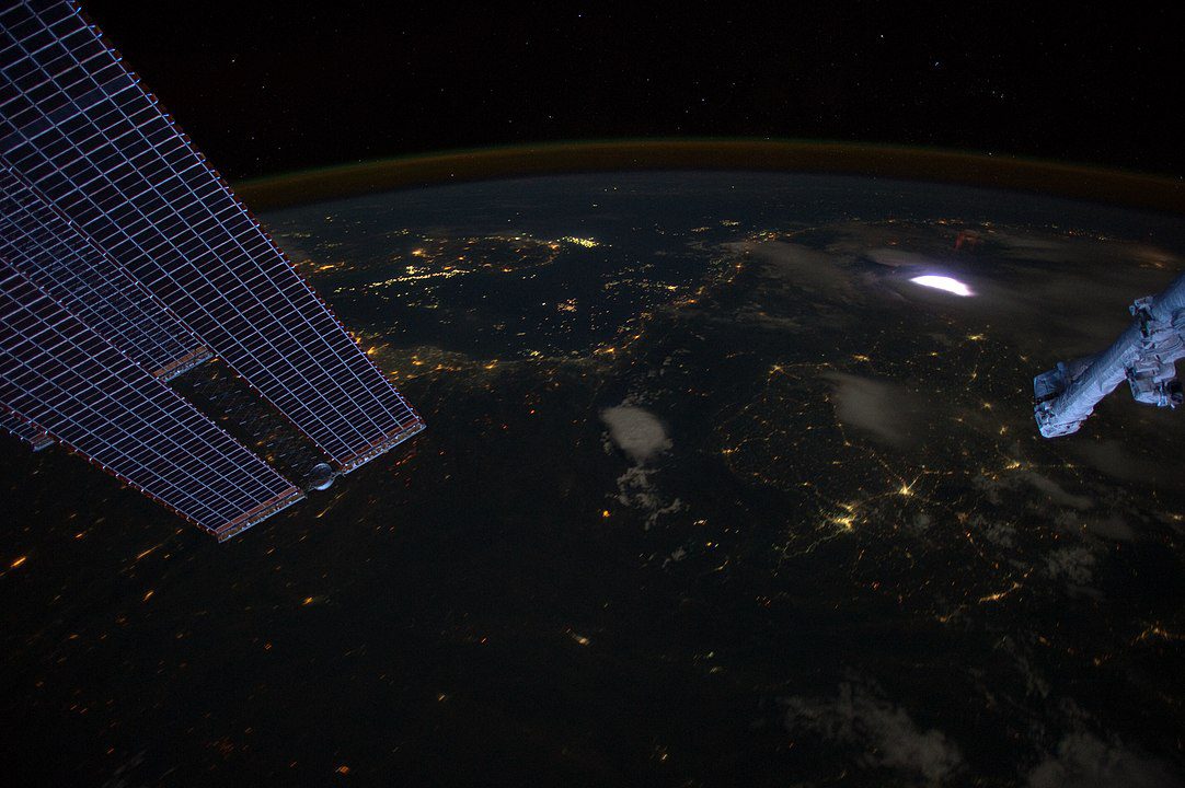
by image science and analysis laboratory, nasa-johnson space center. “the gateway to astronaut photography of earth. ” – http://eol. Jsc. Nasa. Gov/scripts/sseop/photo. Pl? Mission=iss031&roll=e&frame=10712, public domain, https://commons. Wikimedia. Org/w/index. Php? Curid=20255720
Characteristics
Many types of electrical phenomena occur in the atmosphere.
Sprites were observed in North America, Central America and South America. They also occurred over Europe, South America (Zaire), Australia and the Sea of Japan.
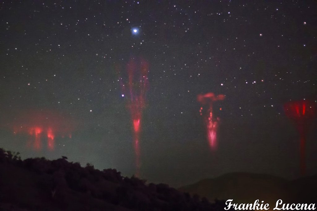
Rodger (1999) classified three types of sprites according to their visual appearance.
- Jellyfish Sprite – Very large, 50 by 50 km (31 x 31 mi)
- Column sprite (C sprite) – is a large-scale electrical discharge above the earth which are still not fully understood.
- A carrot sprite – is a column sprite that has long tendrils.
Sprites can be preceded or followed by a reddish glow. Sprites last longer than the normal lower stratospheric lightning discharges, which can last only a few milliseconds. They are often triggered by positive lightning between the thunderclouds and the ground.
However, sprites created by negative ground flashes also have been seen. They are usually found in groups of two or more and span 50 to 90 km (31 to 56 miles), with what appears to be tendrils hanging below and branches reaching higher.
Optical imaging with a 10,000-frame-per-second high-speed camera revealed that sprites are clusters of small, decameter-sized (10 to 100 m) balls of ionisation. They are launched at an altitude around 80 km (50 miles) and then move down at speeds up to ten per cent of the speed of light.

credit: alamy stock photo
copyright: credit: john sirlin / alamy stock photo
A separate set of upward-moving balls of ionisation follows a few milliseconds later. Horizontal displacement of sprites can be as high as 50 km (31 miles) from the spot of the underlying lightning strike. The time delay after the lightning is usually only a few milliseconds but may sometimes be up to 100 milliseconds.
Special conditions are required to film sprites on Earth:
Clear view of 150-500 km (93-311 miles) to a strong thunderstorm with positive lightning between clouds and ground, red-sensitive recording equipment and a dark unlit sky.
Sprite halo
Sometimes, sprites are preceded by a sprite. This is a region of weak, transient optical emission approximately 50 km (31 mi) across and 10 km (6.2 mi) thick. The centre of the halo lies about 70 km (43 mi) above the lightning strike that initiated it.
These halos are believed to have been created by the same physical process as sprites. Still, the ionisation is too weak for streamer formation. Because of their short duration and similarity in appearance, they are often mistaken for ELVES.
Stanford University’s 2000 research showed that sprite halos are not uncommon in conjunction with normal (negative) lightning discharges. Tohoku University scientists discovered that extremely low-frequency emissions can occur simultaneously with the sprite in 2004. This suggests that the cloud could be responsible for the creation of the sprites.
Aircraft damage
Sprites are blamed for other unexplained accidents that involve high-altitude vehicular operations over thunderstorms. This is evident in the mishap of a NASA stratospheric balloon, which was launched from Palestine, Texas, on June 6, 1989.
Uncommanded payload release occurred at 120,000 feet (37,000m) above a thunderstorm in Texas near Graham. An investigation found that the incident was caused by a bolt of lightning travelling up from the clouds months after the accident. Retroactively, the accident was attributed to a “bolt of lightning” that travelled upward from the clouds. This term was not invented until late 1993.
People Also Ask
Are red sprites dangerous?
These wispy flares, also known as red sprites, can reach up to 60 miles above the cloud’s top. They are usually only good for a short time as they are weakly charged. Red lightning is not considered dangerous.
Are red sprites rare?
The easiest TLE to spot is a red sprite. They’re not uncommon. They aren’t often seen, but that’s because they’re not sought after!
Which is the rarest colour of lightning?
Yellow
This colour is not common, but it can occur when high dust content is in the atmosphere. This can also indicate a dry thunderstorm that has low amounts of precipitation.


