


Introduction
Scud clouds are a fascinating meteorological phenomenon that often leaves people perplexed.
These low-lying, wispy clouds can sometimes be mistaken for something more sinister, like tornadoes or funnel clouds.
In this comprehensive article, we will dive deep into the world of scud clouds, exploring what they are, how they form, and their significance in the realm of weather.
Key Takeaways
Before we delve into the details, let’s summarize the key takeaways about scud clouds:
- Scud clouds are low, ragged clouds that form beneath thunderstorms and other cloud types.
- They are often mistaken for tornadoes or funnel clouds but do not pose a severe weather threat.
- Scud clouds are formed due to turbulence and wind shear associated with thunderstorm downdrafts.
- Understanding scud clouds can help differentiate them from more dangerous weather phenomena.
Now, let’s embark on our journey to unravel the mysteries of scud clouds.

What Are Scud Clouds?
Scud clouds, also known as pannus clouds, are low-lying clouds that form near the ground or just above it.
These clouds have a distinctive appearance, often appearing ragged and wispy, which can lead to confusion with more ominous cloud formations like tornadoes or funnel clouds.
Scud clouds are typically associated with thunderstorms and are formed due to turbulence and wind shear caused by thunderstorm downdrafts and gust front passages.
They are characterized by their low altitude and patchy nature.

How Do Scud Clouds Form?
Understanding the formation of scud clouds requires insight into the dynamics of thunderstorms and the movement of air masses. Here’s a step-by-step explanation of how scud clouds form:
- Thunderstorm Development: Scud clouds are closely linked to thunderstorms. Thunderstorms form when warm, moist air rises and interacts with cooler air, leading to the development of cumulonimbus clouds, which are towering and produce thunder and lightning.
- Turbulence and Wind Shear: Within a thunderstorm, there are various updrafts and downdrafts of air. These movements create turbulence and wind shear, which are changes in wind speed and direction with altitude.
- Interaction with the Surface: As the thunderstorm develops, it often leads to a gust front, a rush of relatively cool air that moves ahead of the storm. This gust front interacts with the warm, moist air near the surface.
- Condensation and Cloud Formation: When the warm, moist air near the surface rises and mixes with the cooler air from the gust front, it cools rapidly. As it cools, the moisture in the air condenses into cloud droplets, forming the scud clouds.
- Ragged Appearance: The turbulent nature of the rising warm air and its interaction with the cooler outflow from the storm leads to the ragged and wispy appearance of scud clouds.
- No Rotation: It’s important to note that scud clouds do not rotate. Unlike tornadoes or funnel clouds, they lack the organized rotation that characterizes these more dangerous weather phenomena.

Differentiating Scud Clouds from Tornadoes and Funnel Clouds
One of the challenges in meteorology is distinguishing between different cloud formations, especially when they appear ominous. Here are some tips to help differentiate scud clouds from tornadoes and funnel clouds:
- Scud clouds lack rotation and do not connect to the base of the thunderstorm. They appear more chaotic and disconnected.
- Tornadoes and funnel clouds, on the other hand, exhibit a smooth, rotating appearance.
- Funnel clouds develop from rotating updrafts and connect to the thunderstorm base. A funnel cloud becomes a tornado when it touches the ground.

Significance in Weather Observation
Scud clouds play a significant role in weather observation, particularly for meteorologists and storm chasers. While they are not associated with severe weather events like tornadoes, their presence can indicate the dynamics within a thunderstorm.
Meteorologists use the appearance and movement of scud clouds to gather information about wind patterns, turbulence, and the overall behavior of a thunderstorm. This data is crucial for understanding and predicting severe weather events.

FAQ
Q1: Are scud clouds dangerous?
No, scud clouds are not dangerous. They are low-lying clouds that form near the ground and are associated with thunderstorms, but they do not pose a severe weather threat.
Q2: Can scud clouds turn into tornadoes?
Scud clouds themselves do not turn into tornadoes. Tornadoes form from rotating updrafts within thunderstorms and are a separate weather phenomenon.
Q3: What is the American Meteorological Society’s role in cloud classification?
The American Meteorological Society (AMS) is involved in the classification and study of clouds. They provide guidelines and standards for cloud classification, helping meteorologists better understand and communicate cloud types.
Q4: How can I differentiate scud clouds from other cloud types?
Scud clouds are characterized by their low altitude, ragged appearance, and association with thunderstorms. They often appear disconnected and lack the organized rotation seen in tornadoes or funnel clouds.
Q5: Do scud clouds indicate severe weather?
While scud clouds themselves do not indicate severe weather, their presence near a thunderstorm can suggest turbulent conditions and provide valuable data for meteorologists monitoring the storm.

Conclusion
Scud clouds are intriguing cloud formations that add complexity to the world of meteorology. While they may resemble more ominous weather phenomena, it’s important to understand that scud clouds are not dangerous on their own.
They are the result of complex interactions within thunderstorms and serve as valuable indicators for meteorologists studying severe weather.
By distinguishing scud clouds from tornadoes and funnel clouds, we can better appreciate the diverse and fascinating world of clouds in our skies.

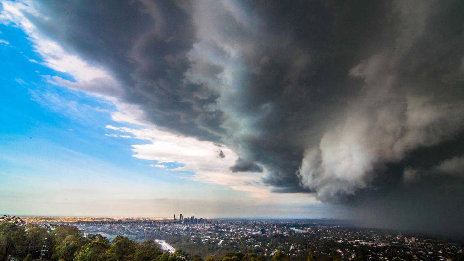
Supercell thunderstorm with associated scud cloud
Sources


